After seasonable, mild days on Sunday and Monday a taste of winter is anticipated across much of Kansas.
According to the National Weather Service, high temperatures will be in the lower 60s both Sunday and Monday before it turns colder Monday evening.
A strong cold front will move south across Kansas on Monday. Temperatures will fall from midday highs in the 60s into the 40s and 50s across northern Kansas. Meanwhile most of the afternoon will stay warm in southern Kansas with highs in the upper 60s to lower 70s.
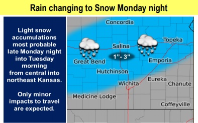
Rain is expected to change to snow or a mix or rain and snow across central and eastern Kansas Monday night into early Tuesday morning. Light snow accumulations of one to three inches are most probable across central into northeast Kansas. Most of the snow accumulations will be on elevated or grassy surfaces. Only minor travel impacts are possible.
The unseasonably cold air mass will settle over the region for Monday night through Wednesday. As a result, overnight and early morning temperatures will likely drop below freezing for many locations. Be prepared to protect any outdoor sensitive plants outside that could be affected by the freezing temperature.