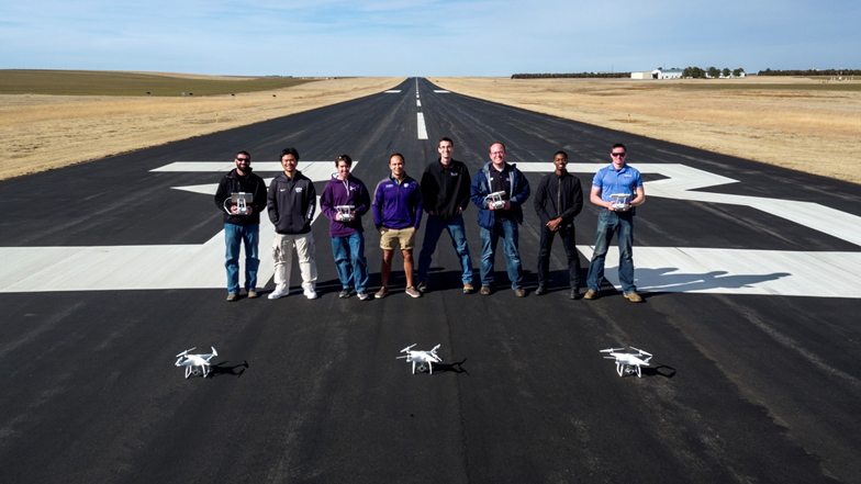
Airport management and unmanned aircraft systems students from the Kansas State University Polytechnic Campus are receiving national recognition for their interdisciplinary research on a current airport industry challenge.
The Airport Cooperative Research Program, which is managed by the Transportation Research Board and sponsored by the Federal Aviation Administration, has selected the team of Kansas State Polytechnic students as second place winners in its annual University Design Competition for Addressing Airport Needs. The five students submitted a project examining an alternative to typical aerial data collection methods at airports titled, “Airport Imagery and Geospatial Data Collection Through the Use of UAS.”
The contest, now in its 11th year, invites collegiate students from across the country to propose innovative designs and practical solutions to various airport issues facing the industry today. All of the proposals, which do not have to originate from an aviation-related degree program, were entered into one of four categories in the competition — Airport Operation and Maintenance, Runway Safety/Runway Incursions/Runway Excursions, Airport Environmental Interactions, and Airport Management and Planning — and awards went to the top three schools of each group. Kansas State Polytechnic took second in the Airport Operation and Maintenance category behind Tufts University.
“This is the first time that any K-State student has entered the ACRP competition, so taking home second place is quite an honor and it reflects strongly on our students’ work ethic, ambitious ideas and ability to problem solve,” said Tara Harl, airport management associate professor and option coordinator at Kansas State Polytechnic. “I think the award also demonstrates the caliber of rigor that the airport management and UAS curriculum provides, giving students the opportunity to engage in real-world projects and gain multiple perspectives by collaborating between majors.”
The research project began when Harl and her counterpart in the UAS degree option decided to merge one of their upper level project-based courses so students could gain a better understanding of each other’s fields of study and how they connect in industry. Four airport management students and one UAS student formed a team and decided to explore if unmanned aircraft are a viable supplement to an airport’s current means of gathering aerial data.
According to the students’ initial analysis, airports use aerial imagery and geospatial data to create an Airport Layout Plan. This blueprint is an in-depth look at the airport’s property and aids in future development and improvement decisions. Images taken overhead also can help in building topography maps that show elevation differences and where issues such as puddling can occur on runways. Generally, aerial data is collected through satellite imagery, light detection and ranging, or LiDAR, or manned aircraft, and the work is usually hired out to third party consultants. As a result of this information, the students wanted to test the idea that unmanned aircraft could be a substitute in that process and possibly make it more cost effective and more efficient.
The students went on to perform a literature review and develop a problem-solving approach. Next, the Kit Carson County Airport in Burlington, Colorado, gave the students permission to use its property to complete a proof-of-concept operation at an active airport. Before flying, the team of students along with faculty members and the Kit Carson airport manager, Daniel Melia, conducted a safety risk assessment. Then, the group surveyed 550 acres of the airport’s property with three unmanned aircraft and captured 2,900 images total, which were later processed into maps in the campus’s UAS lab. The students also interviewed professionals in the industry who provided cost data for the current process and compared it with the team’s sample incurred costs, which yielded significant savings.
At the end of the project, the team of students concluded in its proposal that airport operators can run into high costs trying to obtain updated aerial photography and data collection, and in turn, resign to using old and inaccurate layout plans. The students said industry professionals have identified a need for a lower cost option, especially for quick and small area projects. They said their research successfully demonstrates that UAS technology could be integrated into the data collection process at airports and provide an on-demand option that reduces both cost and risk.
Along with a second-place win, the project also provided students an opportunity to learn how the two worlds of manned and unmanned aviation can safely merge — something David Burchfield, UAS teaching assistant professor, said is imperative in the industry and the classroom.
“The more UAS become integrated into the National Airspace System, the more airports are going to have to know how to accommodate unmanned operations in their airspace and unmanned pilots need to be sensitive to FAA rules about flying near airports,” said Burchfield, who is also the option coordinator for the UAS degree. “This is something we want our students to be proficient in and that’s why we are creating these interdisciplinary learning opportunities. Whenever degrees cross paths with each other, students are exposed to new and relevant ideas that will help them grow academically and become more prepared in their profession.”
“Collaborating with another degree option on this project transformed our education from sitting in a classroom talking about what would be cool to do to executing a project that could make an impact on the airport community,” said Elliot Rogers, a member of the research proposal team and May 2017 bachelor’s graduate in airport management, Davis, California.
The other students involved in the research project include Ryan Thomas, May 2017 bachelor’s graduate in airport management, Atchison; Ian Bonsall, May 2017 bachelor’s graduate in airport management, Goodland; Preston Renfro, May 2017 bachelor’s graduate in unmanned aircraft systems, Dallas, Texas; and Hsin Huang, senior in airport management, Taichung City, Taiwan.
—
Story by Julee Cobb


