Friday is the first official day of Spring, and a wide range of weather will usher it in, including everything from the threat of severe weather to snow.
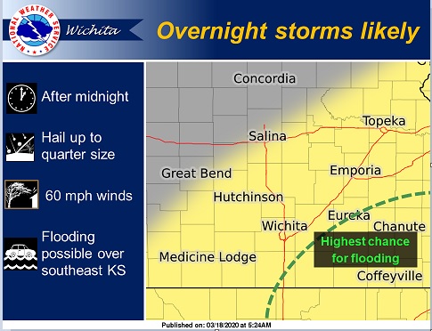
Showers and storms are expected to overspread the area late Wednesday and continue into early Thursday morning.
According to the National Weather Service, the stronger storms will be capable of quarter size hail and 60 mph wind. Flooding will also be possible, with southeast Kansas having the higher chances to see some minor flooding.
Strong southwest winds are expected Thursday afternoon with winds changing to the northwest Thursday evening. Gusts in the 45 to 50 mph range will be likely. Be sure to secure loose outdoor items such as trash containers and furniture. Strong winds will also produce dangerous fire conditions. Outdoor burning is highly discouraged Thursday afternoon and evening.
After a high temperature Thursday reaching into the lower 70s, Friday’s high will only be in the upper 30s.
Other areas in the Midwest are anticipating a winter storm on Friday. Meteorologists say they are expecting an all-out blizzard to unfold over portions of Wyoming, South Dakota, Nebraska and Colorado due to strong wind and a heavy rate of snow Thursday . The winter weather will keep its grip on the that region on Friday, the first full day of spring.


